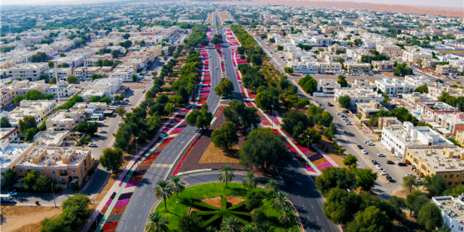
Al Ain, on January 12, Al Ain Municipality completed the aerial photography project, which is one of the operational projects carried out by the municipality, using the latest technologies, as the accuracy of imaging reached between 7 to 10 cm.
The total area of the survey included in the project is estimated at 5,000 square kilometers, covering all urban and semi-urban areas in Al Ain, as part of the municipality’s efforts to provide an accurate database that contributes to supporting studies, planning research and geospatial analyzes to enhance urban growth.
Engineer Mohammed Al-Rashdi, Project Manager at the Spatial Data Department, said that the importance of the project lies in obtaining documented and accurate information that contributes to raising the efficiency of geospatial data, classifying features in the basemap and inventorying assets, by providing a set of primary images, high-definition processed images, aerial lidar points and ground control points in addition to to obtain digital terrain model-corrected images and real digital surface model-corrected images.
He added that the municipality, through the project, implemented several initiatives in the city of Al Ain, such as a project to feed the spatial databases with modern images, in addition to detecting the state of the lands and using the outputs of the project to update the base map that contains all the geospatial information of the landmarks on the surface of the Al Ain region and benefit from them in Current and future planning studies, knowing the locations and heights of all kinds of landmarks.
Al-Rashdi stated that the outputs of the aerial photography project can be used to activate many works that serve the region of the city of Al-Ain, such as automatic detection of changes occurring in the various regions of Al-Ain and determining their type and size, as well as calculating the quantities of excavation and backfilling of lands until the required levels are reached and the detection of the state of the lands. Monitoring distortions, in addition to inventorying assets such as streets of all kinds, lighting poles of all shapes, and directional signs in all areas of Al Ain, and many other uses.
 Media ININ Economy We Trust


